-Sihanoukville Province is a coastal city in Cambodia and the capital of Sihanoukville Province, at the tip of an elevated peninsula in the country's south-west on the Gulf of Thailand. The city is flanked by an almost uninterrupted string of beaches along its entire coastline and coastal marshlands bordering the Ream National Park in the east. The city has one navigable river, the mangrove lined Ou Trojak Jet running from Otres Pagoda to the sea at Otres. A number of thinly inhabited islands – under Sihanoukville's administration[– are near the city, where in recent years moderate development has helped to attract a sizable portion of Asia's individual travelers, students, and backpackers.


Etymology
-The official name of the city in Khmer is: krong ('city'), preah ('holy') Sihanouk (name of the former king), which adds up to: 'City of the holy Sihanouk' or 'Honorable Sihanouk City'. King Norodom Sihanouk (reigned 1941-1955, 1993-2004) was and still is revered as father of the (modern) nation. The name Sihanouk is derived from Sanskrit through two Pali words: siha ('lion'), and hanu ('jaws').
The alternative name, Kompong Saom (also romanized as Kompong Som and Kampong Som), (Khmer: កំពង់សោម) means 'Port of the Moon' or 'Shiva's Port'.[21] Saom is derived from the Sanskrit word saumya, the original (Rig Vedic) meaning of which was Soma, the 'juice or sacrifice of the moon-god', but evolved into Pali 'moon', 'moonlike' 'name of Shiva'. The word kampong or kompong is of Malay origin and means 'village' or 'hamlet'. Its meaning underwent extension towards 'pier' or river 'landing bridge'.
History
Classical period (before 1700)
Prior to the ports' and city's foundation works of 1955, the port of Kompong Som must have been only of regional significance due to the absence of navigable waterways that connect the port with the kingdom's settlement centers. During the many centuries of pre-Angkorian and Angkorian history – from Funan to Chenla and during the Khmer Empire, regional trade was centered at O Keo (Vietnamese: Óc Eo) in the Mekong Delta, now the province of Rạch Giá in Vietnam. The township of Prei Nokor (Saigon) was a commercial center of the Khmer Empire.
The Chronicle of Samtec Cauva Vamn Juon, one of the 18th and 19th century Cambodian Royal Chronicles, briefly mentions the region as the country was split into three parts during a nine year civil war from 1476 to 1485: "In 1479, Dhammaraja took on the throne at Chatomuk (Phnom Penh) and controlled the provinces of Samraong Tong, Thbong, Kompong Saom, Kampot up to the Bassak, Preah Trapeang, Kramuon Sah, Koh Slaket and Peam" (mouth of the Mekong).
After independence (since 1954)
The city's and province's alternative name Kampong som (Kampong Som) was adopted from the local indigenous community. After the dissolution of French Indochina in 1954, it became apparent that the steadily tightening control of the Mekong Delta by Vietnam required a solution to gain unrestricted access to the seas. Plans were made to construct an entirely new deep-water port. Kompong Saom (Kampong Som) was selected for water depth and ease of access. In August 1955, a French/Cambodian construction team cut a base camp into the unoccupied jungle in the area that is now known as Hawaii Beach. Funds for construction of the port came from France and the road was financed by the United States.
During the Vietnam War the port became a military facility for both sides: in the service of National Front for the Liberation of South Vietnam and after 1970, under the government of Lon Nol, in the service of the United States.
The port was the last place to be evacuated by the US Army, only days before Khmer Rouge guerrillas took control of the government in April 1975. The events surrounding the taking of the US container ship SS Mayaguez and its crew on 12 May by the Khmer Rouge and the subsequent rescue operation by US Marines played out on the waters of Koh Tang off the coast of Sihanoukville. During the two days of action, the US commenced air strikes on targets on the mainland of Sihanoukville including the port, the Ream Naval Base, an airfield, the railroad yard and the petroleum refinery in addition to strikes and naval gun fire on several islands.
After the fall of the Khmer Rouge regime in 1979 and the subsequent opening of the economy, the port of Sihanoukville resumed its importance in the development and recovery of the country. With the further opening of new markets in 1999, the city regained its role in the economic growth of Cambodia.
In 1993, Ream National Park was established per royal decree of former King Sihanouk.
The Sihanoukville Municipality was elevated to a regular province on 22 December 2008 after King Norodom Sihamoni signed a royal decree converting the municipalities of Kep, Pailin, and Sihanoukville into provinces.
In 2006 the Koh Puos (Cambodia) Investment Group submitted an application, planning to invest US$276 million in converting the 116 hectare Koh Puos, Snake Island, into a luxury residential and resort complex. After the completion of certain elements of the infrastructure, the investor announced alterations of the original blueprints, as "Reapplying for permission will happen in 2014..." according to the Council of the Development of Cambodia.
On 26 May 2011 Preah Sihanouk area joined the Paris-based club, Les Plus Belles Baies Du Monde, ('the most beautiful bays in the world'). The organisation officially accepted the Bay of Cambodia as one of its members at its 7th General Assembly.
Islands
-All the islands listed below fall under administration of Sihanoukville's Mittakpheap District. The majority is either in the process of or has been assigned for extensive tourism. Koh Rong and Koh Rong Sanloem in particular have so far undergone years of uncoordinated development. A number of guesthouses and bungalow resorts offers accommodation of greatly varying standard by the beaches or in the lush jungle. Despite the very moderate infrastructure, visitor numbers have risen quickly and Koh Rong has been declared a stop on the Banana Pancake Trail.
- Koh Rong, កោះរ៉ុង: Koh Rong, 26 km (16 mi) west of Sihanoukville, is the biggest of the islands of Sihanoukville Province. It encompasses an area of 78 km2 (30 sq mi). The terrain is predominantly hilly with a sizable mountain 316 metres (1,037 ft) at the island's north-west. The hills provide water for creeks, lagoons and estuaries. The island’s interior is almost completely forested. Although there are already lots of guest houses and pubs in and around Koh Tuich village, the island remains virtually deserted – its sheer size dwarfs all settlement centres. As of 2016, there is a well-functioning ferry network between Sihanoukville and Koh Rong.
- Koh Rong Sanloem: South of Koh Rong and smaller beaches are on the west and east coast. It resembles its bigger neighbour Koh Rong in shape and geography – although a bit thinner, it is covered in dense forest, generally more flat (still, though there are sizable hills) and has noticeably less landmass in relation to its coastline. Marine life around Koh Rong Sanloem is very diverse and offers many diving spots. As of 2016, there is a well-functioning ferry network between Sihanoukville and Koh Rong Sanloem.
- Koh Kaong Kang/Thass: Mangrove Island, Ile des Paletuviers (old French name), Koh Kaong Kang/Thass – one of the inner islands – it is a popular place for snorkelers. Koh Kaong Kang/Thass is very flat, hence freshwater is scarce - one of the reasons why nobody lives there permanently.
- Koh Koun: 'Child Island', 'Ile de Cone' (old French name), a small island between Koh Rong and Koh Rong Sanloem, has no beach and is uninhabited.
- Koh Tuich: 'Small Island', a tiny island off Koh Rong's Koh Tuich village. There is a little pagoda on it in service since around 2010.
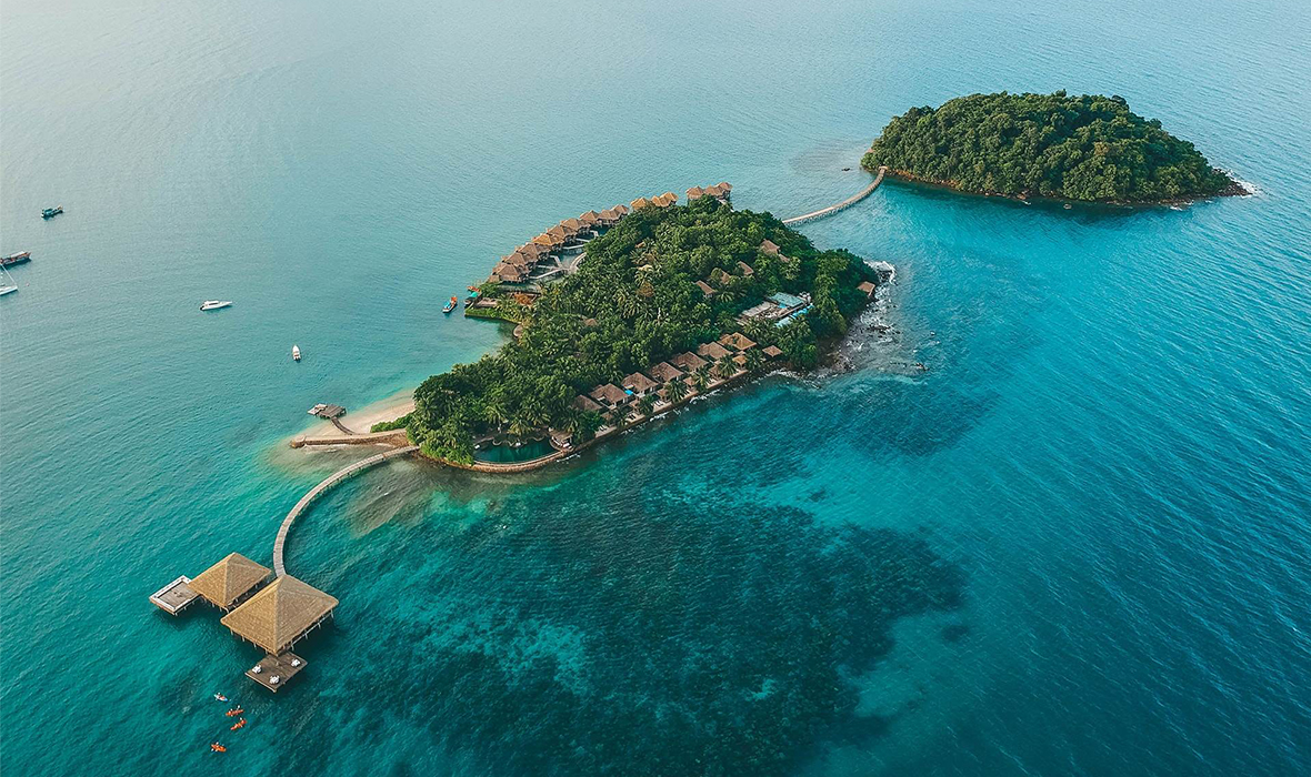
- Koh Puos: also known as 'Snake Island' or 'Morakot Island'. This island lies 800 metres (2,625 ft) off Sihanoukville's Victory Beach. It is under development by Russian investors and converted into a luxury holiday destination and high standard residential area. Snake Island is linked to the mainland via a regular road bridge since around July 2011. The bridge is currently not open for public traffic.
- Koh Dek Koul: This small island lies 7 kilometres (4 mi) off Victory Beach and only a further few hundred metres off Snake Island. The Russian Mirax Luxury Resort corporation operates a hotel business on this predominantly rocky island.
- Koh Bong Po-oun/Song Saa: – 'Siblings/Lovers Islands' – Les Frères (old French name), renamed to Koh Song Saa. Two tiny islets off Koh Rong's north-east.
Map
Comments
Post a Comment